September 14, 2005
cell phone landscape.
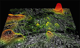
this project from MIT's SENSEable City Laboratory maps a city's cell phone density in real time, by "pinging" the phones anonymously for location.
This topography is overlaid against satellite imagery, cell tower locations/links (i think), and elevation topography.
more images [pdf]
September 02, 2005
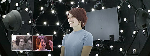
decouple imagery from lighting/environment
nice.
a siggraph paper on capturing all lighting directions 24 times/sec so that one can competely re-light real objects in post. in addition, it grabs an image that can be used as an alpha for complete re-integration into a new environment. animation of the lighting/environment is also possible. and, from the matrix of all lighting directions, they calculate a normal map making it possible to change the surface appearance.
Performance Relighting and Reflectance Transformation with Time-Multiplexed Illumination
video. [101mb divx]